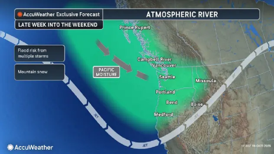
A powerful atmospheric river is expected to sweep into the Pacific Northwest later this week after a brief break from stormy weather, bringing the threat of flooding, damaging winds and heavy mountain snow, according to AccuWeather meteorologists.
The new system marks the start of a series of storms forecast to unleash a deluge of moisture across Washington, Oregon, Idaho, Montana and Wyoming. The storms could cause flooding rainfall, blustery conditions and travel disruptions through the weekend.
Atmospheric River Will Bring Widespread Rain
Early this week, a storm moving southeast from western Canada will bring scattered showers and high-elevation snow across parts of the Northwest before tapering off by Monday morning.
Forecasters said a temporary lull will follow through late Monday and into Tuesday night, allowing for calmer, drier weather and temperatures near seasonal norms. Seattle and Portland are expected to reach daytime highs in the lower to mid-60s during this period.
The quiet spell will end by midweek as a potent storm system moves in from the Pacific.
Rain, according to AccuWeather, will begin Wednesday across southwest British Columbia, Washington and northern Oregon. A stronger system will follow by Thursday that will bring widespread heavy rain and gusty winds.
Wind gusts could reach 50 mph along coastal areas and up to 40 mph inland. Coastal regions of Washington and Oregon could receive 2 to 4 inches of rain through the weekend, with localized totals near 6 inches, while inland areas may see 1 to 2 inches.
“The pattern setting up along the Northwest to Northern California coast is indicative of an atmospheric river, as the moisture can be traced back to Southeast Asia,” said AccuWeather meteorologist Paul Merrill. “This type of pattern typically yields heavy rain and flooding with only very high-elevation snow in the Sierra, given the warm air bleeding into the storm.”
Severe and Extreme Drought
The series of storms could help ease areas of severe and extreme drought across the interior Northwest, but forecasters cautioned that the relief will come with risks of flooding, landslides and travel delays.
Forecaster expect heavy, wet snow in the upper elevations of the Cascades and Sierra Nevada late in the week, potentially lowering to pass level by the weekend as temperatures cool.
Atmospheric rivers are most common from November through January and are known to dump several inches of rain within 24 hours, often triggering flash floods and mudslides. Forecasters said this week’s storm pattern will likely follow that trend.